



Published on: আগ ১৩, ২০২৬ at ১৯:৪৮

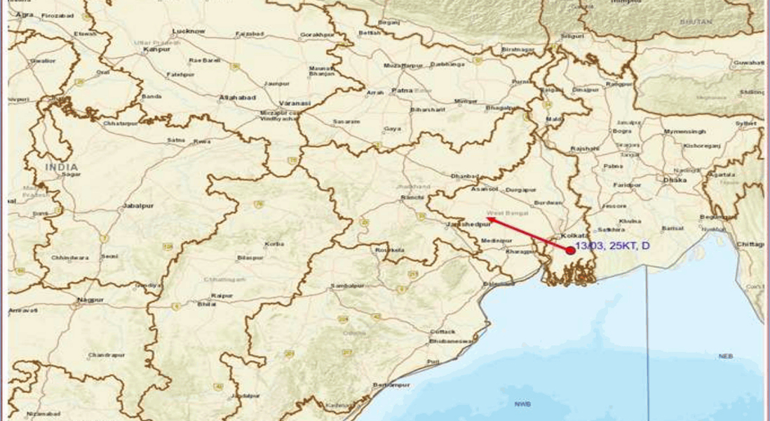
এসপিটি নিউজ, কলকাতা, ১৩ আগস্ট: বঙ্গোপসাগর ও সংলগ্ন বাংলাদেশের উপর তৈরি হওয়া নিম্নচাপটি শক্তি সঞ্চয় করে ‘ডিপ্রেশন’-এ পরিণত হয়েছে। ভারতীয় আবহাওয়া দফতরের কলকাতা আঞ্চলিক কেন্দ্রের ১৩ আগস্টের বিশেষ বুলেটিন অনুযায়ী, বুধবার সকাল সাড়ে ৮টা নাগাদ এই ডিপ্রেশনটি দক্ষিণবঙ্গের উপকূলবর্তী এলাকায়, ক্যানিংয়ের কাছাকাছি অবস্থান করছিল। আগামী ২৪ ঘণ্টায় এটি উত্তর-পশ্চিম দিকে অগ্রসর হয়ে গাঙ্গেয় পশ্চিমবঙ্গ এবং ঝাড়খণ্ডের দিকে এগিয়ে যাওয়ার সম্ভাবনা রয়েছে। এর প্রভাবে দক্ষিণবঙ্গের একাধিক জেলায় ভারী থেকে অতি ভারী বৃষ্টির পাশাপাশি বজ্রবিদ্যুৎ ও দমকা হাওয়ার আশঙ্কা তৈরি হয়েছে।
আবহাওয়া দফতর জানিয়েছে, আগামী ২৪ ঘণ্টায় দক্ষিণবঙ্গের কয়েকটি জায়গায় ৭ থেকে ২০ সেন্টিমিটার পর্যন্ত ভারী থেকে অতি ভারী বৃষ্টি হতে পারে। জঙ্গলমহলের ঝাড়গ্রাম ও পশ্চিম মেদিনীপুরে এক-দু’জায়গায় ২০ সেন্টিমিটারের বেশি অত্যন্ত ভারী বৃষ্টির সম্ভাবনাও রয়েছে। পাশাপাশি পুরুলিয়া, বাঁকুড়া, পূর্ব মেদিনীপুর এবং দক্ষিণ ২৪ পরগনার এক-দু’জায়গায় ৭ থেকে ২০ সেন্টিমিটার পর্যন্ত ভারী থেকে অতি ভারী বৃষ্টি হতে পারে। হাওড়া, হুগলি, কলকাতা, উত্তর ২৪ পরগনা এবং পূর্ব ও পশ্চিম বর্ধমানের কিছু এলাকাতেও ৭ থেকে ১১ সেন্টিমিটার পর্যন্ত ভারী বৃষ্টির সম্ভাবনা রয়েছে।
শুধু বৃষ্টি নয়, ডিপ্রেশনের প্রভাবে বজ্রপাত এবং দমকা হাওয়াও পরিস্থিতি আরও জটিল করতে পারে। দক্ষিণবঙ্গের বিভিন্ন জেলায় ঘণ্টায় ৩০ থেকে ৪০ কিলোমিটার বেগে দমকা হাওয়া বইতে পারে। পূর্ব মেদিনীপুর ও দক্ষিণ ২৪ পরগনায় এক-দু’জায়গায় ঘণ্টায় ৪০ থেকে ৫০ কিলোমিটার বেগে দমকা হাওয়ার সম্ভাবনাও রয়েছে। ঝড়-বৃষ্টির সময় সাধারণ মানুষকে বিশেষ সতর্ক থাকার পরামর্শ দিয়েছে আবহাওয়া দফতর।
বৃহস্পতিবার, ১৪ আগস্টও দক্ষিণবঙ্গের অধিকাংশ জেলায় হালকা থেকে মাঝারি বৃষ্টির সঙ্গে ঝাড়গ্রামে এক-দু’জায়গায় ৭ থেকে ২০ সেন্টিমিটার পর্যন্ত ভারী থেকে অতি ভারী বৃষ্টি হতে পারে। পূর্ব ও পশ্চিম মেদিনীপুর, দক্ষিণ ২৪ পরগনা, বাঁকুড়া, পুরুলিয়া এবং পশ্চিম বর্ধমানের কিছু এলাকাতেও ভারী বৃষ্টির সম্ভাবনা রয়েছে। পূর্ব মেদিনীপুর ও দক্ষিণ ২৪ পরগনার কোথাও কোথাও বজ্রঝড়, বজ্রপাত এবং ঘণ্টায় ৪০ থেকে ৫০ কিলোমিটার বেগে দমকা হাওয়া বইতে পারে।
১৫ আগস্টও দক্ষিণবঙ্গের অধিকাংশ জায়গায় হালকা থেকে মাঝারি বৃষ্টি ও বজ্রবিদ্যুৎ-সহ বৃষ্টির পূর্বাভাস রয়েছে। পূর্ব মেদিনীপুর এবং দক্ষিণ ২৪ পরগনার এক-দু’জায়গায় ৭ থেকে ১১ সেন্টিমিটার পর্যন্ত ভারী বৃষ্টি হতে পারে। একইসঙ্গে দক্ষিণবঙ্গের বিভিন্ন জেলায় বজ্রপাত এবং ঘণ্টায় ৩০ থেকে ৪০ কিলোমিটার বেগে দমকা হাওয়ার সম্ভাবনা রয়েছে।
১৬ আগস্ট দক্ষিণবঙ্গের অনেক জায়গায় বৃষ্টি হতে পারে। পূর্ব মেদিনীপুর, কলকাতা, নদিয়া, মুর্শিদাবাদ, বীরভূম এবং উত্তর ও দক্ষিণ ২৪ পরগনার এক-দু’জায়গায় বজ্রঝড়, বজ্রপাত ও ঘণ্টায় ৩০ থেকে ৪০ কিলোমিটার বেগে দমকা হাওয়ার সম্ভাবনা রয়েছে। ১৭ থেকে ১৯ আগস্টও দক্ষিণবঙ্গের বিভিন্ন জেলায় বৃষ্টি অব্যাহত থাকার পূর্বাভাস দিয়েছে আবহাওয়া দফতর।
অতি বৃষ্টির ফলে দক্ষিণবঙ্গের নিচু এলাকায় জল জমা এবং সাময়িক প্লাবনের আশঙ্কা রয়েছে। ক্ষতিগ্রস্ত হতে পারে কাঁচা রাস্তা, দুর্বল বাড়ি এবং অরক্ষিত কাঠামো। ঝুঁকিপূর্ণ কাঁচা বাড়ির ক্ষেত্রে বাড়তি সতর্কতা প্রয়োজন বলে জানিয়েছে আবহাওয়া দফতর। জলমগ্ন এলাকায় যান চলাচল ও সাধারণ মানুষের গতিবিধি প্রয়োজন অনুযায়ী নিয়ন্ত্রণ করার পরামর্শও দেওয়া হয়েছে। পূর্ব মেদিনীপুর, ঝাড়গ্রাম এবং পশ্চিম মেদিনীপুরের কিছু অংশে আগামী ২৪ ঘণ্টায় নিম্ন থেকে মাঝারি মাত্রার হড়পা বান বা আকস্মিক প্লাবনের ঝুঁকির কথাও উল্লেখ করা হয়েছে।
উত্তরবঙ্গেও আগামী কয়েকদিন আবহাওয়ার পরিস্থিতি পুরোপুরি স্বস্তিদায়ক নয়। ১৩ আগস্ট কালিম্পংয়ে এক-দু’জায়গায় ৭ থেকে ১১ সেন্টিমিটার ভারী বৃষ্টির সম্ভাবনা রয়েছে। ১৪ আগস্ট জলপাইগুড়ি ও আলিপুরদুয়ারে ভারী বৃষ্টির সম্ভাবনা রয়েছে। ১৫ আগস্ট দার্জিলিং ও জলপাইগুড়িতে ভারী বৃষ্টি এবং বজ্রঝড়, বজ্রপাত ও ঘণ্টায় ৩০ থেকে ৪০ কিলোমিটার বেগে দমকা হাওয়ার সম্ভাবনা রয়েছে। ১৬ আগস্ট উত্তরবঙ্গের অধিকাংশ জেলায় হালকা থেকে মাঝারি বৃষ্টির পাশাপাশি জলপাইগুড়ি ও আলিপুরদুয়ারে এক-দু’জায়গায় ৭ থেকে ২০ সেন্টিমিটার পর্যন্ত ভারী থেকে অতি ভারী বৃষ্টি হতে পারে। দার্জিলিং, কালিম্পং ও কোচবিহারেও ভারী বৃষ্টির সম্ভাবনা রয়েছে। মালদহ, উত্তর ও দক্ষিণ দিনাজপুরে বজ্রঝড়, বজ্রপাত ও ঘণ্টায় ৩০ থেকে ৪০ কিলোমিটার বেগে দমকা হাওয়া বইতে পারে।
১৭ আগস্ট উত্তরবঙ্গের জলপাইগুড়ি ও আলিপুরদুয়ারে এক-দু’জায়গায় ৭ থেকে ২০ সেন্টিমিটার পর্যন্ত ভারী থেকে অতি ভারী বৃষ্টির সম্ভাবনা রয়েছে। দার্জিলিং, কালিম্পং ও কোচবিহারেও ভারী বৃষ্টি হতে পারে। ১৮ ও ১৯ আগস্ট জলপাইগুড়ি ও আলিপুরদুয়ারের এক-দু’জায়গায় ৭ থেকে ১১ সেন্টিমিটার পর্যন্ত ভারী বৃষ্টির সম্ভাবনা রয়েছে।
আবহাওয়া দফতরের সতর্কবার্তায় বজ্রপাতের সময় বিশেষ সাবধানতার কথা বলা হয়েছে। খোলা মাঠে থাকা এড়িয়ে নিরাপদ আশ্রয়ে যাওয়ার পরামর্শ দেওয়া হয়েছে। গাছ বা বিদ্যুতের খুঁটির নিচে আশ্রয় না নেওয়া এবং বজ্রঝড়ের সময় জলাশয় বা অন্য কোনও জলাশয়ের সংস্পর্শ এড়িয়ে চলতেও বলা হয়েছে।
এদিকে সমুদ্রও উত্তাল থাকার সম্ভাবনা রয়েছে। ১৩ থেকে ১৪ আগস্ট পশ্চিমবঙ্গ, ওড়িশা ও বাংলাদেশের উপকূল এবং উত্তর বঙ্গোপসাগরে ঘণ্টায় ৪৫ থেকে ৫৫ কিলোমিটার বেগে ঝোড়ো হাওয়া বইতে পারে, যা দমকা হাওয়ার সময় ঘণ্টায় ৬৫ কিলোমিটার পর্যন্ত পৌঁছতে পারে। পরিস্থিতির উন্নতি না হওয়া পর্যন্ত ১৫ আগস্ট পর্যন্ত পশ্চিমবঙ্গ, ওড়িশা ও বাংলাদেশের উপকূল এবং উত্তর বঙ্গোপসাগরে মৎস্যজীবীদের সমুদ্রে না যাওয়ার পরামর্শ দেওয়া হয়েছে। কলকাতা ও হলদিয়া বন্দরে স্থানীয় সতর্কতামূলক সিগন্যাল নম্বর ৩ এবং সাগর আইল্যান্ড বন্দরে সেকশনাল সিগন্যাল নম্বর ১ জারি রাখা হয়েছে।
বুধবার সকাল সাড়ে ৮টা পর্যন্ত পাওয়া বৃষ্টির হিসাবেও দক্ষিণবঙ্গের কয়েকটি এলাকায় উল্লেখযোগ্য বৃষ্টিপাতের ছবি উঠে এসেছে। পূর্ব মেদিনীপুরের দুর্গাচকে ২৪ সেন্টিমিটার এবং কন্টাইয়ে ২০ সেন্টিমিটার বৃষ্টি হয়েছে। দক্ষিণ ২৪ পরগনার ক্যানিংয়ে ১৫ সেন্টিমিটার, সাগরদ্বীপে ১১ সেন্টিমিটার এবং ডায়মন্ড হারবারে ৯ সেন্টিমিটার বৃষ্টি রেকর্ড হয়েছে। পশ্চিম মেদিনীপুরের ঘাটালে ৭ সেন্টিমিটার এবং পূর্ব মেদিনীপুরের আমফু খড়গপুরে ৭ সেন্টিমিটার বৃষ্টির খবর মিলেছে।
সব মিলিয়ে ডিপ্রেশনের প্রভাবে আগামী কয়েকদিন দক্ষিণবঙ্গে বৃষ্টির দাপট অব্যাহত থাকার সম্ভাবনা রয়েছে। বিশেষ করে উপকূল ও জঙ্গলমহলের জেলাগুলিতে ভারী থেকে অতি ভারী বৃষ্টির পাশাপাশি ঝোড়ো হাওয়া ও বজ্রপাতের ঝুঁকি থাকায় সাধারণ মানুষ, পর্যটক, কৃষক এবং সমুদ্রনির্ভর পেশার সঙ্গে যুক্তদের সতর্ক থাকার পরামর্শ দেওয়া হয়েছে।
Published on: আগ ১৩, ২০২৬ at ১৯:৪৮
Depression Over Coastal West Bengal Triggers Heavy Rain Alert Across South Bengal
SPT NEWS,KOLKATA, 13 August — A depression over coastal West Bengal is expected to move northwestward across Gangetic West Bengal and Jharkhand over the next 24 hours, bringing heavy to very heavy rainfall, thunderstorms and gusty winds to several parts of the state, the India Meteorological Department said Wednesday.
The weather system, which developed from a well-marked low-pressure area over coastal West Bengal and adjoining Bangladesh and the northwest Bay of Bengal, was centered around 40 km southeast of Canning in West Bengal at 8:30 a.m. local time on Aug. 13, according to the Regional Meteorological Centre in Kolkata.
The depression is expected to continue moving nearly northwestward, increasing the likelihood of intense rainfall across parts of South Bengal.
The meteorological department forecast heavy to very heavy rainfall of 7 to 20 centimeters at isolated places across several districts during the next 24 hours. Extremely heavy rainfall of more than 20 centimeters was possible at one or two places in Jhargram and West Midnapore districts.
Heavy to very heavy rain was also forecast in isolated areas of Purulia, Bankura, East Midnapore and South 24 Parganas, while Howrah, Hooghly, Kolkata, North 24 Parganas and parts of East and West Burdwan could receive heavy rainfall.
Thunderstorms, lightning and gusty winds are also expected. Winds of 30-40 kph could affect several parts of South Bengal, while gusts of 40-50 kph were possible in isolated areas of East Midnapore and South 24 Parganas.
The weather system is expected to keep South Bengal wet over the next several days. On Aug. 14, heavy to very heavy rainfall could occur in parts of Jhargram, East and West Midnapore, South 24 Parganas, Bankura, Purulia and West Burdwan. Thunderstorms and gusty winds could also affect East Midnapore and South 24 Parganas.
On Aug. 15, heavy rainfall was forecast at isolated places in East Midnapore and South 24 Parganas, accompanied by thunderstorms, lightning and gusty winds across South Bengal.
Rain and thunderstorms are expected to continue on Aug. 16, with isolated thunderstorms, lightning and winds of 30-40 kph possible over East Midnapore, Kolkata, Nadia, Murshidabad, Birbhum and North and South 24 Parganas.
The department has also warned of waterlogging and temporary inundation in low-lying areas, damage to standing crops and horticulture, and possible damage to vulnerable houses, thatched structures and roads.
There is also a risk of flash flooding in parts of East Midnapore, Jhargram and West Midnapore during the following 24 hours, the weather office said.
Authorities have advised residents to seek shelter in safe places during thunderstorms and intense rainfall. People have been warned against taking shelter under trees or near electricity poles and against coming into contact with water bodies during lightning activity.
North Bengal is also expected to experience periods of heavy rainfall through Aug. 19.
Kalimpong could receive heavy rainfall on Aug. 13, while isolated heavy rain was forecast in Jalpaiguri and Alipurduar on Aug. 14. On Aug. 15, Darjeeling and Jalpaiguri could receive heavy rainfall accompanied by thunderstorms, lightning and gusty winds.
On Aug. 16, heavy to very heavy rainfall of 7-20 cm was forecast at isolated places in Jalpaiguri and Alipurduar. Darjeeling, Kalimpong and Cooch Behar could also experience heavy rain, while Malda and the North and South Dinajpur districts could see thunderstorms, lightning and gusty winds.
The rainfall could remain active in Jalpaiguri and Alipurduar on Aug. 17, while heavy rain was also possible in Darjeeling, Kalimpong and Cooch Behar. Further rainfall was forecast in parts of North Bengal on Aug. 18 and 19.
The weather system is also affecting coastal conditions. Squally winds of 45-55 kph, gusting to 65 kph, are expected along and off the coasts of West Bengal, Odisha and Bangladesh and over the north Bay of Bengal through Aug. 14.
The IMD has advised fishermen not to venture into the sea along the coasts of West Bengal, Odisha and Bangladesh or into the north Bay of Bengal until Aug. 15.
Cautionary signals have been maintained at Kolkata and Haldia ports, while a sectional signal has been kept hoisted at Sagar Island port.
Rainfall recorded in the 24 hours ending at 8:30 a.m. on Wednesday reflected the strength of the weather system. Durgachak in East Midnapore recorded 24 cm of rain, followed by Contai with 20 cm. Canning in South 24 Parganas received 15 cm, while Sagar Island recorded 11 cm and Diamond Harbour 9 cm.
The IMD said the southwest monsoon remained active over Gangetic West Bengal, with widespread rainfall across South Bengal and isolated heavy to extremely heavy rainfall in parts of the region.
With the depression expected to move inland, residents in vulnerable and low-lying areas have been urged to remain alert, while local authorities have been advised to regulate movement in waterlogged areas and take precautions in places exposed to flooding, lightning and strong winds.